Tuesday, October 23, 2012

European Space Station keeping an eye on Dutch Dikes

European Space Agency (E.S.A.) is helping the Netherlands by using their InSAR satellite technology, to monitor the nation's dike systems.


Download:
HI-RES JPEG (Size: 1840 kb)

Along the Netherlands’ IJsselmeer dikes, Envisat’s radar detected subsidence of 5 mm per year (in red) during 2003–10.

Credits: GMES/Terrafirma; Envisat ASAR data: ESA

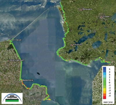
ESA's willingness to use their technology to help monitor dike systems in the Netherlands, may prove to be a life and structure saver.

The dikes are checked physically with routine monitoring, but by being able to observe changes in the water levels, water ways and dikes, by satellite, this will be an effective way, and possible future means of saving or improving such infrastructure.